The CTOH is a French Observation Service dedicated to satellite altimetry studies. The CTOH aims to help scientific users develop new altimetric products and applications.
Within this framework, the CTOH maintains homogeneous altimetric data bases for the long-term monitoring of sea level and ocean currents, lake and river levels, the cryosphère, and the planet’s climate.
The CTOH team collaborates with different scientific investigators to improve the quality of the altimetric measurements and their derived products, and to facilitate their use by scientists.
The CTOH is also an independent centre of expertise for the primary data distribution centres (AVISO for Topex/Poseidon, Jason-1 and ENVISAT in Toulouse; ESA at ESRIN, Italy, and CERSAT for ERS1/2 in Brest), and for preparing future altimetric missions.
Today, new scientific applications for altimetry are appearing : monitoring lake and river levels, the study of the continental snow and the cryosphere, flooded zones, coastal applications. The CTOH contributes to the processing and management of the altimetric data for these “emerging” research domains.
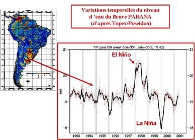
River monitoring
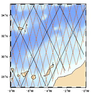
Coastal altimetry
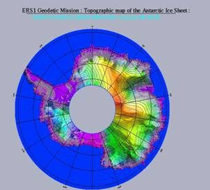
Polar Ice Cap topography
Established in 1989, the CTOH is an INSU service, supported by the Centre National de la Recherche Scientifique (CNRS), Centre National d’Etudes Spatiales (CNES), Observatoire Midi-Pyrénées (OMP), Pôle Océan-Altimétrie-Climat (CPER).
Organisation
Host institution and shareholders
CTOH is hosted at Legos and has an INSU label as an “observation service”.
Contact Form
Please use this form to give us feedback or to submit any special request